


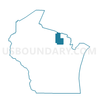
FREEDOM - T 1 Voting District, Forest County, Wisconsin
About
Outline

Summary
| Unique Area Identifier | 693835 |
| Name | FREEDOM - T 1 Voting District |
| County | Forest County |
| State | Wisconsin |
| Area (square miles) | 36.07 |
| Land Area (square miles) | 34.09 |
| Water Area (square miles) | 1.98 |
| % of Land Area | 94.50 |
| % of Water Area | 5.50 |
| Latitude of the Internal Point | 45.43389880 |
| Longtitude of the Internal Point | -88.75312970 |
Maps


Graphs
Select a template below for downloading or customizing gragh for FREEDOM - T 1 Voting District, Forest County, Wisconsin


Neighbors
Neighoring Voting District (by Name) Neighboring Voting District on the Map
- LANGLADE - T 1 Voting District, Langlade County, WI
- LAONA - T3 Voting District, Forest County, WI
- LINCOLN - T 1 Voting District, Forest County, WI
- NASHVILLE - T 2 Voting District, Forest County, WI
- TOWNSEND - T 1 Voting District, Oconto County, WI
- WABENO - T 2 Voting District, Forest County, WI
- WABENO - T 3 Voting District, Forest County, WI
- WABENO - T 4 Voting District, Forest County, WI
- WABENO - T 5 Voting District, Forest County, WI
- WOLF RIVER - T 2 Voting District, Langlade County, WI
Top 10 Neighboring County Subdivision (by Population) Neighboring County Subdivision on the Map
- Laona town, Forest County, WI (1,212)
- Wabeno town, Forest County, WI (1,166)
- Nashville town, Forest County, WI (1,064)
- Townsend town, Oconto County, WI (979)
- Lincoln town, Forest County, WI (955)
- Wolf River town, Langlade County, WI (731)
- Langlade town, Langlade County, WI (473)
- Freedom town, Forest County, WI (345)
Top 10 Neighboring Place (by Population) Neighboring Place on the Map
Top 10 Neighboring Unified School District (by Population) Neighboring Unified School District on the Map
- Antigo School District, WI (17,774)
- Crandon School District, WI (5,554)
- Wabeno Area School District, WI (3,835)
- White Lake School District, WI (1,608)
- Laona School District, WI (1,488)
Top 10 Neighboring State Legislative District Lower Chamber (by Population) Neighboring State Legislative District Lower Chamber on the Map
Top 10 Neighboring State Legislative District Upper Chamber (by Population) Neighboring State Legislative District Upper Chamber on the Map
Top 10 Neighboring 111th Congressional District (by Population) Neighboring 111th Congressional District on the Map
Top 10 Neighboring Census Tract (by Population) Neighboring Census Tract on the Map
- Census Tract 9502, Forest County, WI (2,806)
- Census Tract 1003, Oconto County, WI (2,756)
- Census Tract 9504, Forest County, WI (2,630)
- Census Tract 9503, Forest County, WI (2,608)
- Census Tract 9605, Langlade County, WI (1,880)